


An Imperfect Storm Part Three
Shoreline communities armor up

This post is part of a series on sea level rise. You can read all previous posts on sea level rise here, including An Imperfect Storm and An Imperfect Storm Part Two.
Some recent conversations have thrust sea level rise back into the spotlight as a local front in the culture wars, reminding me that it’s time for an update and some background on the issues. Although I’ll illustrate the story with local examples, the issues are similar for shoreline communities nationwide and beyond.
Sea level rise is happening worldwide. Melting glaciers, and ocean warming from carbon dioxide already in the atmosphere, mean that some further sea level rise is baked in even if carbon dioxide emissions stopped tomorrow. NOAA’s Sea Level Rise and Coastal Flooding Impacts viewer has us, here in Puget Sound, at one foot of sea level rise by 2050, just 25 years from now. That’s in a high scenario. Unfortunately, there is nothing in national or international policy to suggest that we will follow anything less than a high scenario. With the warming that’s driving sea level rise will come more frequent and intense storms causing increasing coastal erosion.
This study, a Puget Sound parcel-scale sea level rise vulnerability assessment from Washington Sea Grant and Coastal Geologic Services, showed that my county is home to half of the top ten percent of Puget Sound parcels most vulnerable to sea level rise and erosion, including those on my neighboring beach. The study assessed vulnerability as a combination of exposure, sensitivity, and adaptive capacity, with a social vulnerability component added in. Exposure here is a measure of the flooding potential under different sea level rise scenarios plus the erosion potential from wind-driven waves during storm events; sensitivity is measure of the effects of exposure on the built environment including accessibility; adaptive capacity is a measure of the feasibility of mitigating these effects by, for example, moving structures further away from the water; and social vulnerability takes into account the vulnerability of the population.
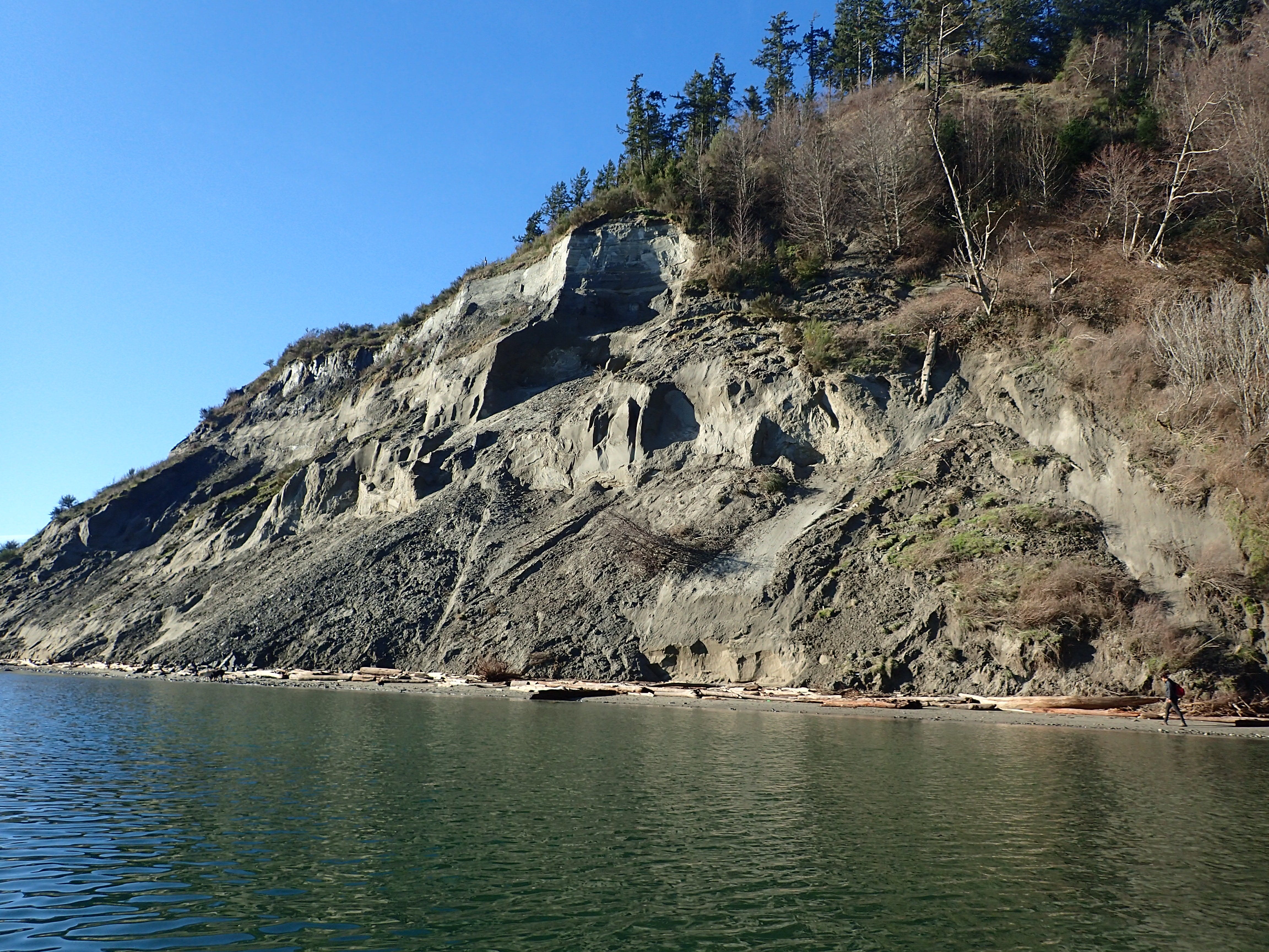
So, why are these parcels so vulnerable? To answer that, we need to take a look at shoreline processes and the history of shoreline development. Beaches and bluffs are dynamically connected. My home of Whidbey Island is composed primarily of glacial till - sand, gravel, and clay deposits left behind by that last glaciation. Where shoreline land is higher, we find bluffs, continuously eroding cliffs, like those near me shown in this photo essay from last year.

These eroding bluffs are known as feeder bluffs, as the eroded material drifts along the shoreline, pushed by wind, waves, and current until it reaches a lower area, where it settles, and wind and waves can push it ashore, forming an accretion beach, named for the way it’s built from drifting sand. The grouping of a feeder bluff with an accretion beach is called a drift cell.
These sandy accretion beaches make ideal recreational beaches. In the early 1900s, my local accretion beach was a sand spit sandwiched between the bay in front and a tide marsh behind. In the early 1900s dikes closed off the tide marsh for agriculture, while on the spit, the landowner built a simple dike of wooden stakes to try the slow the movement of sand and sold off a couple of hundred narrow building lots—on a map they look like piano keys—for $100 each.
Over the years, the handful of duck hunting cabins grew into summer homes, and a community built up. Mom and kids would stay up all summer, while dad would come up at the weekend and maybe Wednesday night. Kids grew up together, became teenagers and adults, and returned to the beach each summer with their own kids. Life was a Norman Rockwell painting.
The sea, however, did not respect the wooden dike, and storms began to erode the beach. Sections of new dike were built, this time from rock, a kind of shoreline armoring known as hard armoring. Unfortunately, hard armoring tends to accelerate beach loss. Waves, instead of running up the beach, losing energy, and depositing sand, bounce off the armoring, the reflected energy carrying sand with it, undermining the rock wall and requiring even more rock.
Accretion beaches are not just a pleasant habitat for humans; they’re a crucial habitat for wildlife. Nesting shore birds, resting marine mammals, fish eggs and crab larvae all use the beach and the intertidal zone. As these become narrower, habitat is diminished. Healthy shorelines are important, important enough that functioning feeder bluffs, drift cells, and intertidal beaches are listed under the Beaches and Marine Vegetation Vital Sign in the Puget Sound Partnership’s Action Agenda, which fulfils its obligations under the Clean Water Act’s National Estuary Program. As these are hard to measure or act on directly, the Habitat Strategic Initiative (I’m currently serving on the Habitat Strategic Initiative Advisory Team) from the State Departments of Fish and Wildlife and Natural Resources chose as a proxy a Shoreline Armoring Implementation Strategy. For indicators, the Partnership likes to have things that can be measured, and so the indicators of success include:
Minimizing miles of new shoreline armor (including from setbacks) and maximizing the miles of shoreline armor removed, sound-wide
Reducing the total extent of shoreline armor sound wide
Increasing the percent of feeder bluffs in functional condition
The danger here is that we wind up only caring about what we can measure, rather than measuring what we truly care about. Nevertheless, a whole industry of consultants, contractors, non-profits, voluntary programs, and a whole regulatory environment sprung up around this strategy’s grant funding, setting the stage for a pitched battle between environmentalists and homeowners, with shoreline armoring as the front, and the County caught in the middle.
In 2017, Island County, including the local beach, was hit by a high tide and storm event that caused overtopping of the dike and consequent flooding, and beach scouring causing loss of beach and undermining of the hard armoring. The community’s response was to demand more armoring. After some temporary drama, an emergency permit was issued, and the sea wall was strengthened.
Then in 2022, a king tide combined with an unusually low atmospheric pressure event produced two feet or storm surge, enough to top the dike in places and to cause emergent groundwater, where the rising sea level lifts the fresh groundwater layer with it until it comes up through the ground. Again, the community is demanding more armor, although that really only protects against erosion and is not much help with sea level rise, and certainly not with emergent groundwater. I covered these events in detail in this essay.

So, is the strategy working? The results are in, and they’re not encouraging. According to the Island County 2023 Shoreline Armor Survey, 2.3 miles of armor were removed in Island County between 2016 and 2023. Unfortunately, 2.6 miles of armor were added for a net increase of 0.3 miles. Also noted was that over 18.8 miles of the total of 51.3 miles of armored shoreline, the armor was closer to the water mostly due to beach erosion. Of the 2.6 miles of new armor, 95% was unpermitted, with 4% having a permit approved and 1% having a permit denied but built anyway. A request for more funding for enforcement was met with polite smiles and nothing more. It’s fair to say that the permit process is not well respected.
Part of the problem is the lack of real alternatives. Let’s take a look at what’s on offer, and why many of these won’t work in this case.
Soft shore armoring is an alternative to hard armoring that builds a more natural shoreline with features such as a gradual slope, driftwood logs, and vegetation to dissipate wave energy. Unfortunately, many of these shoreline communities—designated by the county as Historic Beachfront Communities as they don’t conform to current building regulations—have homes already built within the shoreline setback and are too close to the waterline for that approach to work.
Alas moving houses back further away from the shoreline is also not applicable, as lots are small and the properties are also close to the road.
Large-scale beach replenishment with dredged sand is done elsewhere such as the Jersey Shore, but it’s expensive, needs to be repeated every few years, and smothers what’s left of the habitat.
Houses can be raised on stilts, but it’s not cheap and doesn’t address in-ground infrastructure such as water lines and septic systems, or access roads.
Managed retreat—relocating homes and people away from the shoreline and returning it to nature—is a tough sell. This article—Back off the beach and the rising sea? No way, California cities say - CalMatters—describes the backlash after the City of Imperial Beach, California, suggested such as thing. Our belief in rugged individualism and the privileging of private property rights make this a very heavy lift. Elsewhere in Washington, the Quinault Indian Nation is looking at relocating the villages of Taholah and Queets to higher ground due to sea level rise and tsunami risks.
Property buyouts on the Washington shoreline are further complicated by private ownership of tidelands and a history of beachfront property owners denying access to the beach, to say nothing of a lack of funds for such a program, especially at the county level. Where nearby King County has property tax revenues from Washington businesses that it can use to buy up shoreline properties, Island County relies on property taxes from the same companies' executives' beach front homes to pay for our basic services. A sound-wide state-backed program is needed.
Limiting new development is hard to do, as replacement properties have the planning exceptions of the old properties grandfathered in.
Even when these measures are effective, it’s the poorer people who are relocated while the richer remain, leading to the shoreline gentrification that I wrote about here.

In the absence of any workable alternatives, it’s not a surprise that homeowners continue to demand hard armoring.
All this has created circumstances for a vicious circle. Increased flood risk—all but one of the properties on the local beach are rated 10/10 for flood risk by First Street Foundation—increases insurance premiums and denies mortgages. The legacy owners sell up, tired of floods and high costs, and the only buyers are those who can pay cash. The cabins are torn down and are replaced with larger homes that are become AirBnBs for much of the year. Property taxes increase. The newcomers and AirBnB guests don’t understand the customs of the community. The kids don’t come up anymore. Mom’s working, the grandkids have soccer, vacations are more exotic. They’re getting older, the Norman Rockwell life is disappearing before their eyes, sea level rise is coming, the beach they came to enjoy is washing away. All of these are longer-term problems and hard to reckon with. But the government telling them they can’t install hard armor? That’s an immediate threat to their freedom and private property, something our brains are wired to react to.

Under these circumstances, then, it was brave of a group of county government staff to invite shoreline homeowners from this and a couple of neighboring beaches to a workshop on sea level rise. The first meeting lived up to expectations. There was, as the euphemism goes, a frank exchange of views between the homeowners and some equally passionate members of the environmental community.
How can we move forward? Whidbey Island is a place with a strong sense of community, as I’ve written about in a number of posts over the years. Likewise, the shoreline homeowners, while not participating as much in those broader island communities, have built communities of their own, although the resilience of these is now under threat. Perhaps we can bring those communities together, beach homeowners, beach users, and environmental advocates, overcome rugged individualism and the primacy of private property rights, and begin to work together on community answers to the questions that we should be asking:
How do we want the beach to look in 2050?
How do we get there from here?
and Who’s going to pay for it?
It’s worth a try.
Host
just published the second of our conversations on Whidbey Environmental Action Network’s Action Hour Podcast, this one on sea level rise, in which we cover many of the topics I discuss here. You can listen on Spotify, Apple Music, iHeart Radio, or on WEAN’s website.We’re heading out to Coeur d’Alene, Idaho, this coming weekend, where my wife is competing in the Ironman 70.3 Coeur d'Alene. She’s done this race a couple of times before, but this is my first opportunity to write about it for you. As usual, I’ll be covering the race itself and whatever local water issues find me there. You can read earlier triathlon posts here.
Thanks, as always, for reading or listening. To make sure you don’t miss a post, please consider becoming a free or paid subscriber.
Yesterday I read a NYT article about the old age of our infrastructure, our inability to address it, and the consequences. Government no longer seems to be able to solve big problems. Communities are starved of resources because the people with the money, and who control the money, are undertaxed. The story this essay tells may well be another example of the impact of this breakdown.
What en eloquent telling John, I only wish your subject matter weren't so disconcerting. Hoping for a miracle of cooperation between all invested parties.