This article first ran in December 2022. As we enter storm season here in the Pacific Northwest, it’s timely to post it again—lightly edited with a voiceover added—for Mostly Water’s newer subscribers.
The Storm

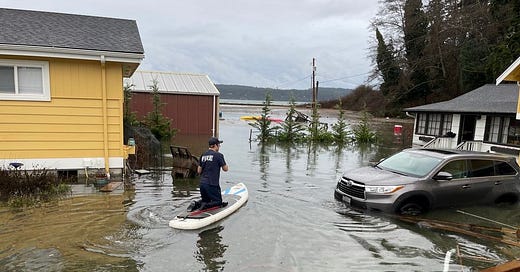
The morning of December 27, 2022 brought a king tide to Washington State's Puget Sound. A storm surge caused by a deep low-pressure system raised the water level by a further two feet. The resulting tidal anomaly caused significant coastal flooding, including around Whidbey Island in Island County, Washington, where many homes have been built on beaches and sand spits. Many of these low-lying communities were impacted. Some residents had to be evacuated, and homes and businesses suffered water damage. Roads were closed in places. Fortunately, there were no reports of loss of life.
The strong winds which accompanied the storm did not coincide with high tide this time, so there was minimal wave overtopping. The winds were a little lighter than those of previous storms which have knocked out power for days, complicating recovery efforts. The weather had also warmed significantly from the previous week when the region was blanketed first in snow and then in freezing rain. It could have been much worse. This was a significant storm but an imperfect storm.
The Models
Several models exist that predict the likelihood of flooding of coastal properties. How did they ride out the storm? Here's a review of three of them.
Our first model comes from a collaborative team from Washington Sea Grant and Coastal Geologic Services, who developed a quantitative approach for calculating sea level rise vulnerability for parcels in the Puget Sound region using publicly available data. The team developed a technical report and user guide, vulnerability assessment maps for each Puget Sound county, and two geodatabase packages for users looking to conduct further analyses. The materials are available here. The project looked at habitat vulnerability as well as infrastructure. (The project was funded by the EPA’s National Estuary Program (NEP) through the Habitat Strategic Initiative at the Washington Department of Fish and Wildlife. I was a member of the advisory team that recommended the project for funding, and later a member of the project advisory team.)
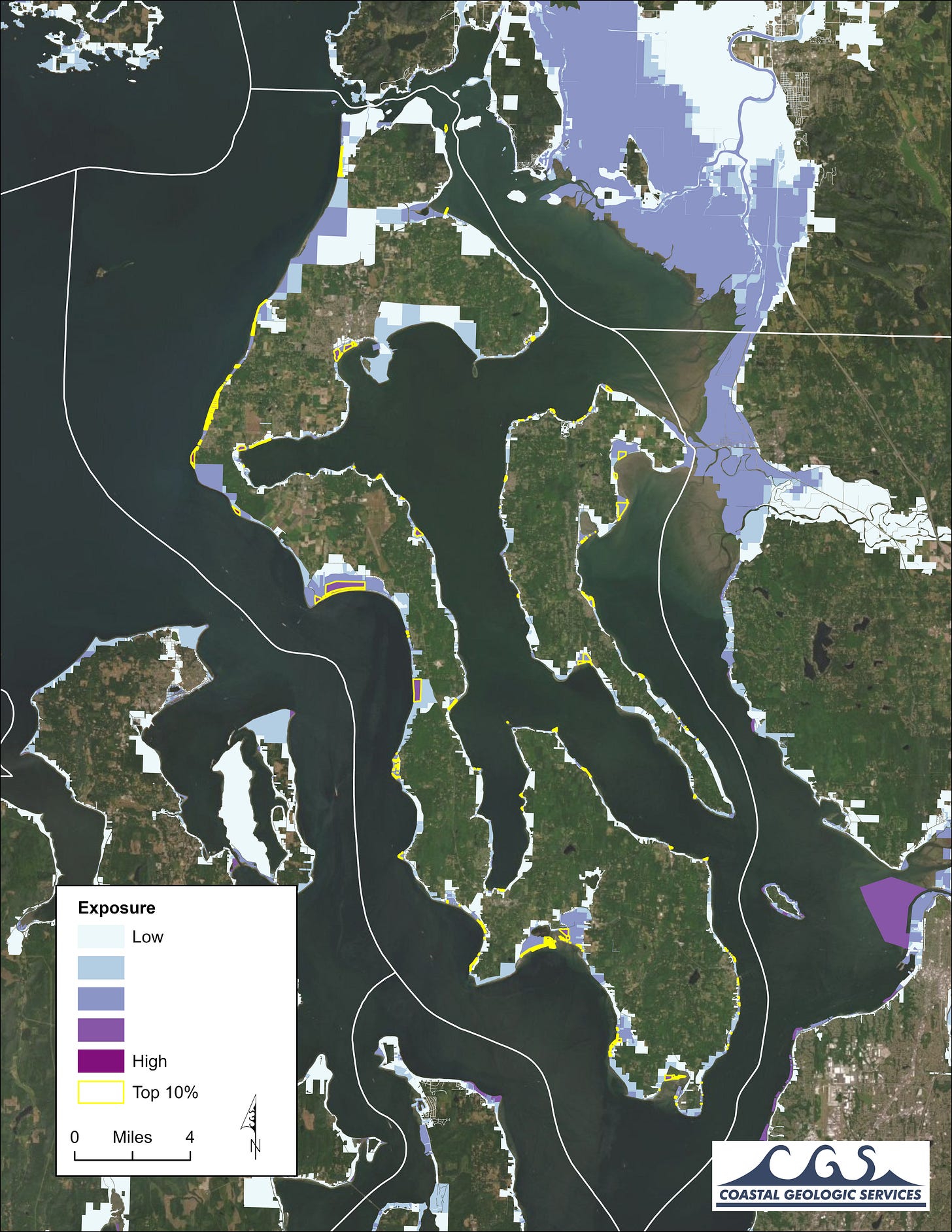
Here is a map showing the level of exposure of parcels in Island County. The top ten percent of parcels with the highest exposure are highlighted in yellow. All the flooding in the recent storm occurred within those areas, and virtually all of them had some flooding.
Our second model, NOAA's Sea Level Rise Viewer looks at the likely effects of sea level rise on coastal flooding. It's at a broader scale than the first model but is nationwide in scope. The results for Island County show that the recent flooding is in line with what would be expected with two feet of sea level rise. That makes sense, as this storm delivered two feet of storm surge!
Our third model, First Street Foundation's Risk Factor, looks at the parcel scale and takes into account information such as flood claims submitted. In one Island County neighborhood, Sunlight Beach (just above Useless Bay in the map above), which suffered flooding during this storm, Risk Factor lists 117 out of 118 homes, along with the road, at extreme risk of flooding.
The Validation
All three of these models accurately predicted the impacts of flooding on shoreline parcels. A foot of sea level rise is expected by 2050. With a foot of sea level rise, today's king tide will be tomorrow’s normal high tide. And two feet of storm surge on top of tomorrow’s king tide will be devastating.
The Perfect Storm
King tides and storms are not independent variables. They both occur most often during the winter. It's only a matter of time before a king tide coincides with a storm surge, wind-driven wave overtopping, a power outage, and winter weather. Climate change is driving sea level rise and causing more frequent and stronger storms, increasing the probability and severity of this perfect storm.
The science is in, the models work, the tools are available, and the predictions are unavoidable. It’s too late for mitigation to save these communities. It's time to start the conversation about adaptation and relocation, who pays, and who benefits. In too many cases, that's been unjust, with poorer people displaced while the rich get to rebuild. The impacts on habitat and public infrastructure are hard to measure and predict and these tend to lose out in planning and funding. Look for a follow up post on climate gentrification.
Update
At least here, the county, towns and cities, and communities are taking these risks seriously, and are starting to have conversations about having the conversation! We’ll get into that more in the follow up post.
Do you live in a community impacted by sea level rise?
Do you use the shoreline for recreation?
What kind of adaptation are you seeing?
Thanks as always for reading or listening. Comments are open, so please join.


Painful issues to address. You have my sympathy. Living in Pittsburgh for most of my 60+ years I’m aware of the flooding history of our three rivers and the extensive mitigation projects over the past century. The catastrophic flood in nearby Johnstown was another lesson in the cost of human folly.
Sounds grim. There's not really much time left to have conversations about having conversations about dealing with the situation.